- Studtman Photo Service, 19th & Lavaca, Austin (x)
- Cartography (x)
- Search results
-

-
Title
-
Survey of 3790 acres belonging to Lawrence Washington and R. Worthington
-
Identifier
-
camh-dob-013623
-
Dates
-
1767
-
Folder
-
SA 1
-
Resource
-
Stephen F. Austin map collection
-
Description
-
Survey of 3790 acres belonging to Lawrence Washington and R. Worthington. 107 x 90 cms.
-

-
Title
-
Survey of a 1/2 League in Gulf Prairie
-
Identifier
-
camh-dob-013731
-
Creator
-
Wightman, Elias R., 1792-1841
-
Dates
-
1832
1832
-
Box
-
3H242
-
Folder
-
Series V: Field Notes, Books 38-54, SA 109 - Field Notes Book 43
-
Resource
-
Stephen F. Austin map collection
-
Description
-
Sketch of a survey of a 1/2 League in Gulf Prairie west of San Bernardo For J.P. Caldwell. 16 x 12 cms. On verso: Mathematical calculations relating to the survey.
-

-
Title
-
Survey of Lands at Mine at Burton & Town Lotts
-
Identifier
-
camh-dob-013627
-
Creator
-
Austin, Moses, 1761-1821
-
Dates
-
1798
-
Box
-
2AA1
-
Folder
-
SA 5, 1798?
-
Resource
-
Stephen F. Austin map collection
-
Description
-
Survey of lands at Potosi. 32 x 38.5 cms. 1 inch = 200 feet
-

-
Title
-
Survey of Matagorda Bay
-
Identifier
-
camh-dob-013682
-
Creator
-
Austin, Stephen F. (Stephen Fuller), 1793-1836
-
Dates
-
1828
-
Box
-
2AA1
-
Folder
-
SA 60, 1828?
-
Resource
-
Stephen F. Austin map collection
-
Description
-
Survey of Matagorda Bay with distances noted. 33 x 19.5 cms.
-

-
Title
-
Texas
-
Identifier
-
foth_0091
-
Creator
-
Burr, David H., 1803-1875
-
Dates
-
1834
-
Description
-
David H. Burr created the first large scale map of Texas extending to the Arkansas River in the Texas panhandle. As with his 1833 edition of the map, Burr shows the division of Texas lands into seventeen different grants, one of which is the De León Colony.
-

-
Title
-
Texas map collection
-
Identifier
-
camh_voc_029294
-

-
Title
-
Thomas J. Pilgrim's 500 A Tract Out of League No. 60
-
Identifier
-
camh-dob-013723
-
Creator
-
Wightman, Elias R., 1792-1841
-
Dates
-
1830
-
Box
-
3H242
-
Folder
-
Series V: Field Notes, books 38-54, SA 101 - Field Notes Book 45
-
Resource
-
Stephen F. Austin map collection
-
Description
-
Survey of Thomas J. Pilgrim's 500 acre tract out of League No. 60. 23 x 14 cms. On verso: Field notes.
-

-
Title
-
U.S.G.S./Army Corps of Engineers historic topographic map collection
-
Identifier
-
camh_voc_029310
-

-
Title
-
Earl Vandale map collection
-
Identifier
-
camh_voc_029304
-
-
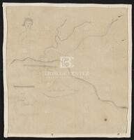
Title
-
Washington City, District of Columbia
-
Identifier
-
camh-dob-013642
-
Creator
-
Austin, Stephen F. (Stephen Fuller), 1793-1836
-
Dates
-
1823
-
Box
-
2AA1
-
Folder
-
SA 19, 1823?; SA 20, 1824?; SA 47, 1828; SA 50, 1828?; SA 59, 1828?; SA 107, 1832, SA 19, 1823?
-
Resource
-
Stephen F. Austin map collection
-
Description
-
Sketch of Washington City, District of Columbia, in pencil. Contains two drawings of banners, one with "Washington City, District of Columbia" written in it, and the other saying "San Felipe de Austin." Also includes a drawing of a man, possibly intended to be George Washington. 19.5 x 20 cms.
