- Documentary Photography (x)
- Cartography (x)
- Politics and Elections (x)
- Search results
-
-
Title
-
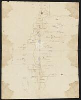
Actual work to Correct the Maps by Cronkrite
-
Identifier
-
camh-dob-013650
-
Creator
-
Austin, Stephen F. (Stephen Fuller), 1793-1836
-
Dates
-
1824
-
Resource
-
Stephen F. Austin map collection
-
Description
-
Sketch of plats along the upper Tres Palacios Creek in Matagorda and Waller Counties. 32 x 40.2 cms. On verso: Actual work to correct the maps by Cronkite.
-

-
Title
-
The Bingamen Bottom Place
-
Identifier
-
camh-dob-013624
-
Creator
-
Austin, Moses, 1761-1821
-
Dates
-
1791
-
Resource
-
Stephen F. Austin map collection
-
Description
-
Sketch of survey of Bingamen Bottom Place in Wythe County, Virginia. 25 x 24 cms. In colored outline.
-

-
Title
-
Caldwell Survey
-
Identifier
-
camh-dob-013726
-
Creator
-
Wightman, Elias R., 1792-1841
-
Dates
-
1831
-
Resource
-
Stephen F. Austin map collection
-
Description
-
Sketch of survey of Cedar Lake and Bernard showing J.P. Caldwell's survey. 30 x 36 cms.
-

-
Title
-
Capt. Adams Draft of the Coasts and Bay, Corpus Christy, 1827
-
Identifier
-
camh-dob-013743
-
Creator
-
Austin, Stephen F. (Stephen Fuller), 1793-1836
-
Dates
-
1827, 1827
-
Resource
-
Stephen F. Austin map collection
-
Description
-
Draft of the Coasts and Bay, Corpus Christy. This map was found by a patron in a different collection and is believed to be a map from the Stephen F. Austin Collection. 32 x 30 cms. On verso: "Capt. Adams Draft of the Coast and Bay, Corpus Christy, 1827" inscription.
-

-
Title
-
Cedar Lake Survey
-
Identifier
-
camh-dob-013654
-
Dates
-
1826
-
Resource
-
Stephen F. Austin map collection
-
Description
-
Survey of Cedar Lake area including timberland and marshland or wet prairie. 35 x 20 cms. On verso: "Cedar Lake Survey" inscription.
-

-
Title
-
John V. Clay map collection
-
Identifier
-
camh_voc_029305
-

-
Title
-
Copias de los diarios de operaciones des occurridas en este destacamto
-
Identifier
-
camh-dob-013653
-
Dates
-
1824, 1824
-
Resource
-
Stephen F. Austin map collection
-
Description
-
Sketch of the Villa de San José de Palafox. Inscribed on verso in Spanish with "Copias de los diarios de operaciones des occurridas en este destacamto... 13 oficios del...de la linea...en tiempo...Capt. Barragan." 31 x 21.5 cms. Note: The Villa is adjacent to Presidio de Rio Grande. See Bastrop's letter to Ceballos, 22 August 1825, in Barker, The Austin Papers, I, 965.
-

-
Title
-
Cyprus Bayou Survey on the North prong of the above
-
Identifier
-
camh-dob-013656
-
Creator
-
Austin, Stephen F. (Stephen Fuller), 1793-1836
-
Dates
-
1827
-
Resource
-
Stephen F. Austin map collection
-
Description
-
Cyprus Bayou Survey on the North prong of the above. Shows plats of Matthew Burnet and Francis Simmons. 19.5 x 12.5 cms.
-

-
Title
-
Field Book for Surveys of Partition Work
-
Identifier
-
camh-dob-013715
-
Creator
-
Wightman, Elias R., 1792-1841
-
Dates
-
1829, 1829
-
Resource
-
Stephen F. Austin map collection, Austin papers
-
Description
-
Pamphlet of survey notes and sketches of plats.
-

-
Title
-
Field Notes, Book 16
-
Identifier
-
camh-dob-013712
-
Creator
-
Wightman, Elias R., 1792-1841
-
Dates
-
1831
-
Resource
-
Stephen F. Austin map collection, Austin papers
-
Description
-
Pamphlet of survey notes and sketches of plats.
-

-
Title
-
Field notes of a League of Land belonging to the Heirs of William Whiteside
-
Identifier
-
camh-dob-013690
-
Creator
-
Austin, Stephen F. (Stephen Fuller), 1793-1836
-
Dates
-
1830
-
Resource
-
Stephen F. Austin map collection
-
Description
-
Field notes and sketch of a League of land belonging to the heirs of William Whiteside in Waller County along the Brazos River. Two separated pages.
-

-
Title
-
Field notes of a survey of land by Ingram
-
Identifier
-
camh-dob-013652
-
Creator
-
Selkirk, William, 1792–1830
-
Contributor
-
Ingram, Seth, 1790-1857
-
Dates
-
1824
-
Resource
-
Stephen F. Austin map collection
-
Description
-
Sketch and field notes of 44th and 45th Leagues, land belonging to Mr. Williams and Mr. Rabb. 14 x 5 cms.
-

-
Title
-
Field Notes on Lands in S. F. Austin's Colonies, 1825
-
Identifier
-
camh-dob-013687
-
Creator
-
Austin, Stephen F. (Stephen Fuller), 1793-1836
-
Contributor
-
Borden, Thomas Henry, 1804-1877
-
Dates
-
1852
-
Resource
-
Stephen F. Austin map collection, Austin papers
-
Description
-
Pamphlet of survey notes and sketches of plats.
-

-
Title
-
Genaro García map collection
-
Identifier
-
camh_voc_029308
-

-
Title
-
Harry E. Moore map collection
-
Identifier
-
camh_voc_029284
-

-
Title
-
Pearl Hendricks map collection
-
Identifier
-
camh_voc_029307
-

-
Title
-
J. P. Bryan map collection
-
Identifier
-
camh_voc_029285
-

-
Title
-
Jones Plott
-
Identifier
-
camh-dob-013648
-
Creator
-
Austin, Stephen F. (Stephen Fuller), 1793-1836
-
Dates
-
1824
-
Resource
-
Stephen F. Austin map collection
-
Description
-
Sketch of Jones plot in Wharton County with notes and calculations. 23.2 x 36.8 cms. Some lines drawn in pencil.
-

-
Title
-
Map collection
-
Identifier
-
camh_voc_029287
-

-
Title
-
Map of a part of DeWitt's Colony
-
Identifier
-
camh-dob-013684
-
Creator
-
Austin, Stephen F. (Stephen Fuller), 1793-1836
-
Dates
-
1829
-
Resource
-
Stephen F. Austin map collection
-
Description
-
Sketch of Colorado and Rio Grande Rivers with notes. On verso: Map of a part of DeWitt's Colony, showing the area about Gonzales, Bastrop and DeWitt's Station. 28 x 26 cms.
