- Photography (x)
- Cartography (x)
- 1824 (x)
- Search results
-

-
Title
-
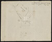
Annotated map from Army Corp of Engineers depicting the improvements needed for the Sabine Neches waterway, circa 1953
-
Identifier
-
camh-dob-001455
-
Topic
-
United States--Sabine-Neches Waterway, Intracoastal waterways
-
Dates
-
1953
-
Box
-
2007-255/5
-
Folder
-
Sabine Neches Waterway, Dec 52 Thru Sept 53
-
Resource
-
Jack B. Brooks papers
-
Description
-
The map, originally printed by the Army Corps of Engineers in 1938, depicts the Sabine-Neches waterway and the surrounding area. The locations of proposed improvements to the waterway are marked in red pencil.
-

-
Title
-
The Bingamen Bottom Place
-
Identifier
-
camh-dob-013624
-
Creator
-
Austin, Moses, 1761-1821
-
Dates
-
1791
-
Box
-
2AA1
-
Folder
-
SA 2, 1791?
-
Resource
-
Stephen F. Austin map collection
-
Description
-
Sketch of survey of Bingamen Bottom Place in Wythe County, Virginia. 25 x 24 cms. In colored outline.
-

-
Title
-
Caldwell Survey
-
Identifier
-
camh-dob-013726
-
Creator
-
Wightman, Elias R., 1792-1841
-
Dates
-
1831
-
Box
-
2AA1
-
Folder
-
SA 104, 1831?
-
Resource
-
Stephen F. Austin map collection
-
Description
-
Sketch of survey of Cedar Lake and Bernard showing J.P. Caldwell's survey. 30 x 36 cms.
-

-
Title
-
Capt. Adams Draft of the Coasts and Bay, Corpus Christy, 1827
-
Identifier
-
camh-dob-013743
-
Creator
-
Austin, Stephen F. (Stephen Fuller), 1793-1836
-
Dates
-
1827
1827
-
Box
-
2AA1
-
Folder
-
SA 121, 1827?
-
Resource
-
Stephen F. Austin map collection
-
Description
-
Draft of the Coasts and Bay, Corpus Christy. This map was found by a patron in a different collection and is believed to be a map from the Stephen F. Austin Collection. 32 x 30 cms. On verso: "Capt. Adams Draft of the Coast and Bay, Corpus Christy, 1827" inscription.
-

-
Title
-
Cedar Lake Survey
-
Identifier
-
camh-dob-013654
-
Dates
-
1826
-
Box
-
2AA1
-
Folder
-
Field Notes Book 124 - Cedar Lake Survey - SA 31, 1826?
-
Resource
-
Stephen F. Austin map collection
-
Description
-
Survey of Cedar Lake area including timberland and marshland or wet prairie. 35 x 20 cms. On verso: "Cedar Lake Survey" inscription.
-

-
Title
-
John V. Clay map collection
-
Identifier
-
camh_voc_029305
-
-
Title
-
Cyprus Bayou Survey on the North prong of the above
-
Identifier
-
camh-dob-013656
-
Creator
-
Austin, Stephen F. (Stephen Fuller), 1793-1836
-
Dates
-
1827
-
Box
-
3H242
-
Folder
-
Series V: Field Notes, books 38-54, SA 33
-
Resource
-
Stephen F. Austin map collection
-
Description
-
Cyprus Bayou Survey on the North prong of the above. Shows plats of Matthew Burnet and Francis Simmons. 19.5 x 12.5 cms.
-
-
Title
-
Field Book for Surveys of Partition Work
-
Identifier
-
camh-dob-013715
-
Creator
-
Wightman, Elias R., 1792-1841
-
Dates
-
1829
1829
-
Box
-
3H241
-
Folder
-
Series V: Field Notes, books 16-37, Pamphlet - Field Notes Book 17
-
Resource
-
Stephen F. Austin map collection, Austin papers
-
Description
-
Pamphlet of survey notes and sketches of plats.
-
-
Title
-
Field Notes, Book 16
-
Identifier
-
camh-dob-013712
-
Creator
-
Wightman, Elias R., 1792-1841
-
Dates
-
1831
-
Box
-
3H241
-
Folder
-
Series V: Field Notes, books 16-37, Pamphlet - Field Notes Book 16 [contains part of book 13]
-
Resource
-
Stephen F. Austin map collection, Austin papers
-
Description
-
Pamphlet of survey notes and sketches of plats.
-

-
Title
-
Field notes of a League of Land belonging to the Heirs of William Whiteside
-
Identifier
-
camh-dob-013690
-
Creator
-
Austin, Stephen F. (Stephen Fuller), 1793-1836
-
Dates
-
1830
-
Box
-
3H242
-
Folder
-
Series V: Field Notes (2 of 2), SA 68
-
Resource
-
Stephen F. Austin map collection
-
Description
-
Field notes and sketch of a League of land belonging to the heirs of William Whiteside in Waller County along the Brazos River. Two separated pages.
-

-
Title
-
Field Notes on Lands in S. F. Austin's Colonies, 1825
-
Identifier
-
camh-dob-013687
-
Creator
-
Austin, Stephen F. (Stephen Fuller), 1793-1836
-
Contributor
-
Borden, Thomas Henry, 1804-1877
-
Dates
-
1852
-
Box
-
3H242
-
Folder
-
Series V: Field Notes, Books 55-126, SA 85, 105, 108, 1825
-
Resource
-
Stephen F. Austin map collection, Austin papers
-
Description
-
Pamphlet of survey notes and sketches of plats.
-

-
Title
-
Genaro García map collection
-
Identifier
-
camh_voc_029308
-
-
Title
-
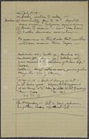
Handwritten notes, July 26, 1974
-
Identifier
-
camh-dob-001885
-
Creator
-
Brooks, Jack, 1922-2012
-
Topic
-
United States Congress. House. Committee on the Judiciary, Impeachment
-
Dates
-
1974-07-26
-
Box
-
2007-255/329
-
Folder
-
File VI
-
Resource
-
Jack B. Brooks papers
-
Description
-
Handwritten notes regarding articles of impeachment and votes in the House Judiciary Committee. Authorship is unclear, but these notes may have been written by Jack Brooks.
-

-
Title
-
Harry E. Moore map collection
-
Identifier
-
camh_voc_029284
-

-
Title
-
Pearl Hendricks map collection
-
Identifier
-
camh_voc_029307
-

-
Title
-
J. P. Bryan map collection
-
Identifier
-
camh_voc_029285
-

-
Title
-
Major industries, waterways & highways, Port Arthur, Beaumont, Orange, & Lake Charles areas, undated
-
Identifier
-
camh-dob-001463
-
Topic
-
Intracoastal waterways, Industries
-
Box
-
2007-255/5
-
Folder
-
Lake Sabine, Jan 1958 to
-
Resource
-
Jack B. Brooks papers
-
Description
-
A detailed map depicting the various industries in the area and the locations of these industries in relation to waterways and roads. Port Arthur, Beaumont, and Orange were fledgling industrial centers in Jack Brooks's district. Brooks played an integral role working with his constituents to appropriate federal funding for projects that would benefit industry, including the Sabine-Neches waterway and the McGee Bend Dam.
-

-
Title
-
Map collection
-
Identifier
-
camh_voc_029287
-

-
Title
-
Map of a part of DeWitt's Colony
-
Identifier
-
camh-dob-013684
-
Creator
-
Austin, Stephen F. (Stephen Fuller), 1793-1836
-
Dates
-
1829
-
Box
-
2AA1
-
Folder
-
SA 62, 1829[?]
-
Resource
-
Stephen F. Austin map collection
-
Description
-
Sketch of Colorado and Rio Grande Rivers with notes. On verso: Map of a part of DeWitt's Colony, showing the area about Gonzales, Bastrop and DeWitt's Station. 28 x 26 cms.
-

-
Title
-
Map of a Part of Northern Coahuila
-
Identifier
-
camh-dob-013668
-
Creator
-
Austin, Stephen F. (Stephen Fuller), 1793-1836
-
Dates
-
1828
-
Box
-
2AA1
-
Folder
-
SA 46, 1828?
-
Resource
-
Stephen F. Austin map collection
-
Description
-
Map of a Part of Northern Coahuila, Mexico showing roads, rivers, and basic topography. 43.5 x 32.5 cms.
