- Mexico (Republic) (x)
- Politics and Elections (x)
- Maps (documents) (x)
- Search results
-
-
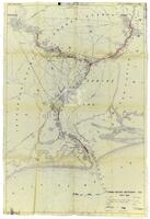
Title
-
Annotated map from Army Corp of Engineers depicting the improvements needed for the Sabine Neches waterway, circa 1953
-
Identifier
-
camh-dob-001455
-
Topic
-
United States--Sabine-Neches Waterway, Intracoastal waterways
-
Dates
-
1953
-
Box
-
2007-255/5
-
Folder
-
Sabine Neches Waterway, Dec 52 Thru Sept 53
-
Resource
-
Jack B. Brooks papers
-
Description
-
The map, originally printed by the Army Corps of Engineers in 1938, depicts the Sabine-Neches waterway and the surrounding area. The locations of proposed improvements to the waterway are marked in red pencil.
-
-
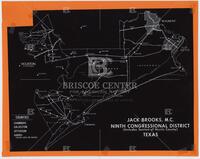
Title
-
Jack Brooks, M.C., Ninth Congressional District map, undated
-
Identifier
-
camh-dob-001198
-
Topic
-
Elections
-
Box
-
2007-255/754
-
Folder
-
59
-
Resource
-
Jack B. Brooks papers
-
Description
-
The new map for Jack Brooks's district after redistricting took place in Texas as a result of the Bush v Martin Supreme Court decision. Brooks had previously represented the 2nd congressional district and represented the 9th district for the rest of his career.
-

-
Title
-
Map of Texas congressional districts, June 2, 1965
-
Identifier
-
camh-dob-001445
-
Topic
-
Elections, Legislation
-
Dates
-
1965-06-02
-
Box
-
2007-255/129
-
Folder
-
122.33
-
Resource
-
Jack B. Brooks papers
-
Description
-
An annotated map depicting proposed redistricting plans for Texas.
-

-
Title
-
Map of Texas congressional districts, June 23, 1965
-
Identifier
-
camh-dob-001446
-
Topic
-
Elections, Legislation
-
Dates
-
1965-06-23
-
Box
-
2007-255/129
-
Folder
-
122.33
-
Resource
-
Jack B. Brooks papers
-
Description
-
A map depicting final redistricting plans for Texas Congressional districts.
