- Texas History (x)
- Cartography (x)
- Austin, Stephen F. (Stephen Fuller), 1793-1836 (x)
- Search results
-
-
Title
-
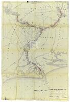
Annotated map from Army Corp of Engineers depicting the improvements needed for the Sabine Neches waterway, circa 1953
-
Identifier
-
camh-dob-001455
-
Topic
-
United States--Sabine-Neches Waterway, Intracoastal waterways
-
Dates
-
1953
-
Resource
-
Jack B. Brooks papers
-
Description
-
The map, originally printed by the Army Corps of Engineers in 1938, depicts the Sabine-Neches waterway and the surrounding area. The locations of proposed improvements to the waterway are marked in red pencil.
-

-
Title
-
Caldwell Survey
-
Identifier
-
camh-dob-013726
-
Creator
-
Wightman, Elias R., 1792-1841
-
Dates
-
1831
-
Resource
-
Stephen F. Austin map collection
-
Description
-
Sketch of survey of Cedar Lake and Bernard showing J.P. Caldwell's survey. 30 x 36 cms.
-

-
Title
-
Cedar Lake Survey
-
Identifier
-
camh-dob-013654
-
Dates
-
1826
-
Resource
-
Stephen F. Austin map collection
-
Description
-
Survey of Cedar Lake area including timberland and marshland or wet prairie. 35 x 20 cms. On verso: "Cedar Lake Survey" inscription.
-

-
Title
-
Copias de los diarios de operaciones des occurridas en este destacamto
-
Identifier
-
camh-dob-013653
-
Dates
-
1824, 1824
-
Resource
-
Stephen F. Austin map collection
-
Description
-
Sketch of the Villa de San José de Palafox. Inscribed on verso in Spanish with "Copias de los diarios de operaciones des occurridas en este destacamto... 13 oficios del...de la linea...en tiempo...Capt. Barragan." 31 x 21.5 cms. Note: The Villa is adjacent to Presidio de Rio Grande. See Bastrop's letter to Ceballos, 22 August 1825, in Barker, The Austin Papers, I, 965.
-

-
Title
-
Copy Photo: Garden plat, Santa Luisa, Brownsville
-
Identifier
-
RUN07790
-
Creator
-
Runyon, Robert
-
Resource
-
Robert Runyon photograph collection
-

-
Title
-
Copy Photo: Map of La Carbonera and El Cureno, January 1899
-
Identifier
-
RUN07791
-
Creator
-
Runyon, Robert
-
Resource
-
Robert Runyon photograph collection
-
-
Title
-
Copy Photo: Map of state of Tamaulipas, Mexico
-
Identifier
-
RUN07792
-
Creator
-
Runyon, Robert
-
Resource
-
Robert Runyon photograph collection
-

-
Title
-
Field Book for Surveys of Partition Work
-
Identifier
-
camh-dob-013715
-
Creator
-
Wightman, Elias R., 1792-1841
-
Dates
-
1829, 1829
-
Resource
-
Stephen F. Austin map collection, Austin papers
-
Description
-
Pamphlet of survey notes and sketches of plats.
-

-
Title
-
Field Notes, Book 16
-
Identifier
-
camh-dob-013712
-
Creator
-
Wightman, Elias R., 1792-1841
-
Dates
-
1831
-
Resource
-
Stephen F. Austin map collection, Austin papers
-
Description
-
Pamphlet of survey notes and sketches of plats.
-
-
Title
-
Field notes of a survey of land by Ingram
-
Identifier
-
camh-dob-013652
-
Creator
-
Selkirk, William, 1792–1830
-
Contributor
-
Ingram, Seth, 1790-1857
-
Dates
-
1824
-
Resource
-
Stephen F. Austin map collection
-
Description
-
Sketch and field notes of 44th and 45th Leagues, land belonging to Mr. Williams and Mr. Rabb. 14 x 5 cms.
-
-
Title
-
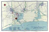
Major industries, waterways & highways, Port Arthur, Beaumont, Orange, & Lake Charles areas, undated
-
Identifier
-
camh-dob-001463
-
Topic
-
Intracoastal waterways, Industries
-
Resource
-
Jack B. Brooks papers
-
Description
-
A detailed map depicting the various industries in the area and the locations of these industries in relation to waterways and roads. Port Arthur, Beaumont, and Orange were fledgling industrial centers in Jack Brooks's district. Brooks played an integral role working with his constituents to appropriate federal funding for projects that would benefit industry, including the Sabine-Neches waterway and the McGee Bend Dam.
-
-
Title
-
Map of Luke Moore Tract & Field Notes
-
Identifier
-
camh-dob-013738
-
Creator
-
Lott, H., active 1830-1840 (Surveyor)
-
Dates
-
1838, 1838
-
Resource
-
Stephen F. Austin map collection
-
Description
-
Survey of a tract of land on Brays Bayou for the heirs of S. F. Austin. 32 x 20 cms.
-

-
Title
-
Map of Oyster Lake and adjacent area showing the H. Curtis Labor
-
Identifier
-
camh-dob-013737
-
Dates
-
1837, 1837
-
Resource
-
Stephen F. Austin map collection
-
Description
-
Map of Oyster Lake and adjacent area showing the H. Curtis Labor. 21 x 32 cms. On verso: notes and calculations.
-

-
Title
-
Map of Texas
-
Identifier
-
foth_0631_multipage
-
Creator
-
Galli, Fiorenzo
-
Dates
-
1826
-
Description
-
Map of Texas surrounded by text
-
-
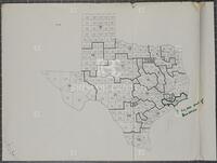
Title
-
Map of Texas congressional districts, June 2, 1965
-
Identifier
-
camh-dob-001445
-
Topic
-
Elections, Legislation
-
Dates
-
1965-06-02
-
Resource
-
Jack B. Brooks papers
-
Description
-
An annotated map depicting proposed redistricting plans for Texas.
-

-
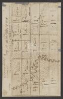
Title
-
Map of the correction when the leagues were run in to the meanders of San Jacinto
-
Identifier
-
camh-dob-013708
-
Dates
-
1830
-
Resource
-
Stephen F. Austin map collection
-
Description
-
Correcting map of plats near the San Jacinto river. 39.5 x 27 cms. Verso is inscribed with "Map of correction when The Leagues were run in to the meanders of San Jacinto."
-
-
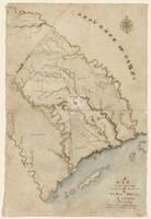
Title
-
A map of the country, between the Brassos & La Baca Rivers By N. Rightor
-
Identifier
-
camh-dob-013637
-
Creator
-
Rightor, Nicholas
-
Dates
-
1822, 1822
-
Resource
-
Stephen F. Austin map collection
-
Description
-
A map of the Province of Texas, between the Brazos & Lavaca Rivers. Details the major waterways in the southeast region of Texas as they flow into the Gulf of Mexico. Hand drawn, in colors. Water is shaded blue. 1 inch = 10 miles. 24.2 x 36.6 cms.
-

-
Title
-
A map of the country between the Brassos and La Baca Rivers
-
Identifier
-
foth_0178
-
Creator
-
Rightor, Nicholas
-
Dates
-
1822
-
Description
-
Nicholas Rightor is considered the first American to survey the Texas coast and to produce a sketch of the central region of Austin's 1821 land grant. The map shows in some detail the land from the La Baca (Lavaca) to the Brazos, with various descriptions of the river and the country.
-

-
Title
-
Map of the head waters of San Jacinto disjoined from the other surveys
-
Identifier
-
camh-dob-013711
-
Dates
-
1830
-
Resource
-
Stephen F. Austin map collection
-
Description
-
Map of plats inscribed with "This map is the head waters of San Jacinto disjoined from the other surveys. Only a connecting line runs to prove its relative situation, called upper surveys." Shows plats of Susan Vince, James Ford, and heirs of William Hodge. May be missing pieces. 39 x 35 cms. Shading in pencil.
-
-
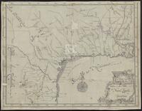
Title
-
Mapa Geographico de las Provincias Septentrionales de esta Nueva España
-
Identifier
-
camh-dob-013632
-
Creator
-
Puelles, José María de Jesús 1772-1840
-
Dates
-
1807
-
Resource
-
Stephen F. Austin map collection
-
Description
-
Map of the Gulf of Mexico and surrounding areas, including Mexico, the province of Texas, Louisiana, and western Florida. 54.3 x 42 cms. Boundaries colored.
