- Austin, Stephen F. (Stephen Fuller), 1793-1836 (x)
- Austin papers (x)
- Manuscript maps (x)
- Search results
-

-
Title
-
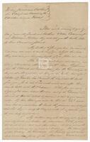
Address and wax seal for letter from Stephen F. Austin to Thomas F. Learning, Address and wax seal for letter from Stephen F. Austin to Thomas F. Learning
-
Identifier
-
di_11063
-
Creator
-
Austin, Stephen F. (Stephen Fuller), 1793-1836
-
Dates
-
1831-03-15
-
Resource
-
Thomas F. Learning papers
-

-
Title
-
Address to the Central Committee
-
Identifier
-
foth_0237_multipage
-
Creator
-
Austin, Stephen F. (Stephen Fuller), 1793-1836
-
Dates
-
1833-04
-
Description
-
Stephen F. Austin delivered an address to the "Gentlemen of the Convention," citing reasons for Texas separating from Coahuila.
-
-
Title
-
Austin to Cherokee Chiefs
-
Identifier
-
foth_0221_multipage
-
Creator
-
Austin, Stephen F. (Stephen Fuller), 1793-1836
-
Dates
-
1827-01-24
-
Description
-
Stephen F. Austin addresses his letter to his "friends and Brothers, the Chiefs and Warriors of the Cherokee living in Texas." Austin cautions the Cherokee against siding with the Nacogdoches men leading the rebellion against Mexico.
-

-
Title
-
Civil Commandant of the Colony forming on the Colorado and Brassos Rivers, in the Province of Texas . . .
-
Identifier
-
foth_0022
-
Creator
-
Austin, Stephen F. (Stephen Fuller), 1793-1836
-
Dates
-
1821
-
Description
-
Upon returning to New Orleans after an initial survey of Texas in the summer of 1821, Stephen F. Austin issued this permit stating the terms under which Austin would admit settlers to the colony. The formal procedure for an immigrant seeking admission to Austin's Colony required that he present himself to Austin upon arrival, register his name, and take an oath to support the federal and state constitutions. He thus became an applicant and was given a permit to select land. The settler then was required to give notice of his choice of land within thirty days and to petition for the land. Instructions were then issued to the surveyor to survey and plat the land and, upon payment of fees, the commissioner issued the title.
-

-
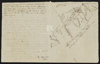
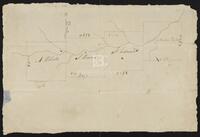
Title
-
Cyprus Bayou Survey on the North prong of the above
-
Identifier
-
camh-dob-013656
-
Creator
-
Austin, Stephen F. (Stephen Fuller), 1793-1836
-
Dates
-
1827
-
Resource
-
Stephen F. Austin map collection
-
Description
-
Cyprus Bayou Survey on the North prong of the above. Shows plats of Matthew Burnet and Francis Simmons. 19.5 x 12.5 cms.
-

-
Title
-
Field notes of a League of Land belonging to the Heirs of William Whiteside
-
Identifier
-
camh-dob-013690
-
Creator
-
Austin, Stephen F. (Stephen Fuller), 1793-1836
-
Dates
-
1830
-
Resource
-
Stephen F. Austin map collection
-
Description
-
Field notes and sketch of a League of land belonging to the heirs of William Whiteside in Waller County along the Brazos River. Two separated pages.
-

-
Title
-
Field Notes on Lands in S. F. Austin's Colonies, 1825
-
Identifier
-
camh-dob-013687
-
Creator
-
Austin, Stephen F. (Stephen Fuller), 1793-1836
-
Contributor
-
Borden, Thomas Henry, 1804-1877
-
Dates
-
1852
-
Resource
-
Stephen F. Austin map collection, Austin papers
-
Description
-
Pamphlet of survey notes and sketches of plats.
-
-
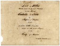
Title
-
A List of Titles Made Under the Special Contract with the State of Coahuila and Texas by Stephen F. Austin 1828 to Settle 300 Families within the Ten Border Leagues on the Gulf of Mexico
-
Identifier
-
foth_0641_multipage
-
Creator
-
Austin, Stephen F. (Stephen Fuller), 1793-1836
-
Dates
-
1833
-
Description
-
Title page of the List; Ledger recording the first settlers in Austin's original colony. Those settlers, the first Americans to settle in Texas legally, are known today as the Old Three Hundred. Austin's original plan for land distribution was superseded by a colonization law in 1823 by which each family received not less than one labor (177 acres) or one league (4428 acres) of land depending on whether the head of household was a farmer or stockman. Commissioner Baron de Bastrop issued the lands and titles to settlers designated by Austin. The three hundred families were nearly all in Texas by 1824, and the work of issuing the titles continued until 1827. One of the premier documents of Texas history, Austin's ledger lists the name of the settler and designates the location and quantities of land and the date of title.
-

-
Title
-
Map of Texas by Stephen F. Austin
-
Identifier
-
foth_0630
-
Creator
-
Austin, Stephen F. (Stephen Fuller), 1793-1836
-
Dates
-
1829
-
Description
-
Austin's detailed hand-drawn map showing the Austin and DeWitt colonies, various towns and rivers, and other natural features in Texas. Austin prepared the map sometime between 1823 and 1828 and based the map on firsthand observations as well as information gathered from travelers and surveyors.
-

-
Title
-
Map of Texas With Parts of the Adjoining States
-
Identifier
-
foth_0634
-
Creator
-
Austin, Stephen F. (Stephen Fuller), 1793-1836
-
Dates
-
1835
-
Description
-
The 1835 edition of Austin's 1830 Map of Texas, the first map to show on a large scale the beginnings of immigration into Texas from the United States. This later edition depicts additional land grants and presents a section of text stating the number of families to be located on each grant shown on the map.
-
-
Title
-
Nueces below La Bahia and Laredo road from M. Lion
-
Identifier
-
camh-dob-013674
-
Creator
-
Austin, Stephen F. (Stephen Fuller), 1793-1836
-
Dates
-
1828
-
Resource
-
Stephen F. Austin map collection
-
Description
-
Sketch of Nueces below La Bahia and Laredo road, with notes. 15.4 x 16 cms. On verso: Field notes.
-
-
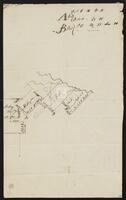
Title
-
Plat of Land on Oyster Creek
-
Identifier
-
camh-dob-013706
-
Creator
-
Austin, Stephen F. (Stephen Fuller), 1793-1836
-
Dates
-
1830
-
Resource
-
Stephen F. Austin map collection
-
Description
-
Sketch of a plat of land on Oyster Creek in Brazoria County, showing the SFA, Grace E. Waller, and Asa Mitchell plats. 32 x 17 cms.
-
-
Title
-
Plotts of Spring Creek
-
Identifier
-
camh-dob-013661
-
Creator
-
Austin, Stephen F. (Stephen Fuller), 1793-1836
-
Dates
-
1827
-
Resource
-
Stephen F. Austin map collection
-
Description
-
Plotts of Spring Creek showing the land of A. Roberts, S. Brown, J. Edwards, and Matthew Hubert. 28 x 13 cms.
-

-
Title
-
Prison diary
-
Identifier
-
foth_0035_multipage
-
Creator
-
Austin, Stephen F. (Stephen Fuller), 1793-1836
-
Dates
-
1835
-
Description
-
The small diary Austin smuggled into prison to record his thoughts and experiences during the nearly two years he was confined. The diary contains an inscription dated December 25, 1871, by Moses Austin Bryan, Austin's nephew, stating that he traced in ink over Austin's original pencil writings "which were made by him in this book whilst he was a prisoner in the cell no. 15 ... I have heard my Uncle Austin speak of this book that he managed to secret with a pencil when his person was examined."
-
![Prison Diary [facsimile]](/islandora/object/islandora%3A420126/datastream/TN/view?solr_nav%5Bid%5D=43c04e58b1aaee4cf261&solr_nav%5Bpage%5D=0&solr_nav%5Boffset%5D=14)
-
Title
-
Prison Diary [facsimile]
-
Identifier
-
foth_0646
-
Creator
-
Austin, Stephen F. (Stephen Fuller), 1793-1836
-
Dates
-
1835
-
Description
-
Two pages from the small diary Stephen F. Austin smuggled into prison to record his thoughts and experiences during the nearly two years he was confined. This page includes a drawing of Austin's prison environment.
-

-
Title
-
Proclamation
-
Identifier
-
foth_0179_multipage
-
Creator
-
Austin, Stephen F. (Stephen Fuller), 1793-1836
-
Dates
-
1824-05-01
-
Description
-
Austin's announcement to the members of his colony that the Mexican Congress had adopted a Federal Republican system of government and that the "hitherto enslaved Spanish Provinces are now free and independent States."
-
![Project [?] of a Consitution for the Republic of Mexico](/islandora/object/islandora%3A419475/datastream/TN/view?solr_nav%5Bid%5D=43c04e58b1aaee4cf261&solr_nav%5Bpage%5D=0&solr_nav%5Boffset%5D=16)
-
Title
-
Project [?] of a Consitution for the Republic of Mexico
-
Identifier
-
foth_0607_multipage
-
Creator
-
Austin, Stephen F. (Stephen Fuller), 1793-1836
-
Dates
-
1823-03-30
-
Description
-
Project [?] of a Consitution for the Republic of Mexico
-
-
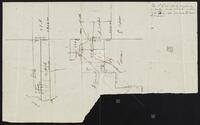
Title
-
Rough Plot of McElroy's Hill's and for finding corners
-
Identifier
-
camh-dob-013673
-
Creator
-
Austin, Stephen F. (Stephen Fuller), 1793-1836
-
Dates
-
1828
-
Resource
-
Stephen F. Austin map collection
-
Description
-
Rough plot of McElroy's Hill's and for finding corners. Shows plats of McElroy (McLeroy), McLaughlin, Hill, Wright and Kuykendall (Keykendall). 25 x 16 cms.
-

-
Title
-
A rough topographical sketch of the route or different routes from the Rio Grande to the Capital or City of Mexico
-
Identifier
-
camh-dob-013735
-
Creator
-
Austin, Stephen F. (Stephen Fuller), 1793-1836
-
Dates
-
1836, 1836
-
Resource
-
Stephen F. Austin map collection
-
Description
-
A rough topographical sketch of the route or different routes from the Rio Grande to the Capital or City of Mexico, with written directions and suggestions for military movements through the area. This is a sketch of the proposed invasion routes for the Army of the U.S. 20 x 18.8 cms.
-

-
Title
-
Sketch of a proposed Fort at Velasco(?)
-
Identifier
-
camh-dob-013635
-
Creator
-
Austin, Stephen F. (Stephen Fuller), 1793-1836
-
Dates
-
1822, 1822
-
Resource
-
Stephen F. Austin map collection
-
Description
-
Sketch of a proposed Fort at Velasco(?), with notes. 55.4 x 44 cms. Colored with shading. On verso: Elevation plan of fort with notes.
