- Studtman Photo Service, 19th & Lavaca, Austin (x)
- Broadside collection, Eberstadt collection (x)
- Texas History (x)
- 1935-1936 (x)
- Cartography (x)
- Maps (documents) (x)
- Search results
-

-
Title
-
Annotated map from Army Corp of Engineers depicting the improvements needed for the Sabine Neches waterway, circa 1953
-
Identifier
-
camh-dob-001455
-
Topic
-
United States--Sabine-Neches Waterway, Intracoastal waterways
-
Dates
-
1953
-
Box
-
2007-255/5
-
Folder
-
Sabine Neches Waterway, Dec 52 Thru Sept 53
-
Resource
-
Jack B. Brooks papers
-
Description
-
The map, originally printed by the Army Corps of Engineers in 1938, depicts the Sabine-Neches waterway and the surrounding area. The locations of proposed improvements to the waterway are marked in red pencil.
-

-
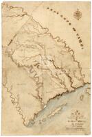
Title
-
Map of Texas by Stephen F. Austin
-
Identifier
-
foth_0630
-
Creator
-
Austin, Stephen F. (Stephen Fuller), 1793-1836
-
Dates
-
1829
-
Folder
-
SA 64
-
Description
-
Austin's detailed hand-drawn map showing the Austin and DeWitt colonies, various towns and rivers, and other natural features in Texas. Austin prepared the map sometime between 1823 and 1828 and based the map on firsthand observations as well as information gathered from travelers and surveyors.
-
-
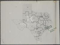
Title
-
Map of Texas congressional districts, June 2, 1965
-
Identifier
-
camh-dob-001445
-
Topic
-
Elections, Legislation
-
Dates
-
1965-06-02
-
Box
-
2007-255/129
-
Folder
-
122.33
-
Resource
-
Jack B. Brooks papers
-
Description
-
An annotated map depicting proposed redistricting plans for Texas.
-

-
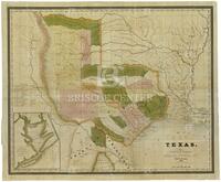
Title
-
Map of Texas With Parts of the Adjoining States
-
Identifier
-
foth_0634
-
Creator
-
Austin, Stephen F. (Stephen Fuller), 1793-1836
-
Dates
-
1835
-
Description
-
The 1835 edition of Austin's 1830 Map of Texas, the first map to show on a large scale the beginnings of immigration into Texas from the United States. This later edition depicts additional land grants and presents a section of text stating the number of families to be located on each grant shown on the map.
-
-
Title
-
A map of the country between the Brassos and La Baca Rivers
-
Identifier
-
foth_0178
-
Creator
-
Rightor, Nicholas
-
Dates
-
1822
-
Description
-
Nicholas Rightor is considered the first American to survey the Texas coast and to produce a sketch of the central region of Austin's 1821 land grant. The map shows in some detail the land from the La Baca (Lavaca) to the Brazos, with various descriptions of the river and the country.
-
-
Title
-
Texas
-
Identifier
-
foth_0091
-
Creator
-
Burr, David H., 1803-1875
-
Dates
-
1834
-
Description
-
David H. Burr created the first large scale map of Texas extending to the Arkansas River in the Texas panhandle. As with his 1833 edition of the map, Burr shows the division of Texas lands into seventeen different grants, one of which is the De León Colony.
