- Studtman Photo Service, 19th & Lavaca, Austin (x)
- Broadside collection, Eberstadt collection (x)
- Texas History (x)
- 1951 (x)
- Cartography (x)
- Austin, Stephen F. (Stephen Fuller), 1793-1836 (x)
- Search results
-

-
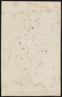
Title
-
Actual work to Correct the Maps by Cronkrite
-
Identifier
-
camh-dob-013650
-
Creator
-
Austin, Stephen F. (Stephen Fuller), 1793-1836
-
Dates
-
1824
-
Box
-
2AA1
-
Folder
-
SA 27, 1824?
-
Resource
-
Stephen F. Austin map collection
-
Description
-
Sketch of plats along the upper Tres Palacios Creek in Matagorda and Waller Counties. 32 x 40.2 cms. On verso: Actual work to correct the maps by Cronkite.
-

-
Title
-
Capt. Adams Draft of the Coasts and Bay, Corpus Christy, 1827
-
Identifier
-
camh-dob-013743
-
Creator
-
Austin, Stephen F. (Stephen Fuller), 1793-1836
-
Dates
-
1827
1827
-
Box
-
2AA1
-
Folder
-
SA 121, 1827?
-
Resource
-
Stephen F. Austin map collection
-
Description
-
Draft of the Coasts and Bay, Corpus Christy. This map was found by a patron in a different collection and is believed to be a map from the Stephen F. Austin Collection. 32 x 30 cms. On verso: "Capt. Adams Draft of the Coast and Bay, Corpus Christy, 1827" inscription.
-

-
Title
-
Cyprus Bayou Survey on the North prong of the above
-
Identifier
-
camh-dob-013656
-
Creator
-
Austin, Stephen F. (Stephen Fuller), 1793-1836
-
Dates
-
1827
-
Box
-
3H242
-
Folder
-
Series V: Field Notes, books 38-54, SA 33
-
Resource
-
Stephen F. Austin map collection
-
Description
-
Cyprus Bayou Survey on the North prong of the above. Shows plats of Matthew Burnet and Francis Simmons. 19.5 x 12.5 cms.
-

-
Title
-
Field notes of a League of Land belonging to the Heirs of William Whiteside
-
Identifier
-
camh-dob-013690
-
Creator
-
Austin, Stephen F. (Stephen Fuller), 1793-1836
-
Dates
-
1830
-
Box
-
3H242
-
Folder
-
Series V: Field Notes (2 of 2), SA 68
-
Resource
-
Stephen F. Austin map collection
-
Description
-
Field notes and sketch of a League of land belonging to the heirs of William Whiteside in Waller County along the Brazos River. Two separated pages.
-
-
Title
-
Field Notes on Lands in S. F. Austin's Colonies, 1825
-
Identifier
-
camh-dob-013687
-
Creator
-
Austin, Stephen F. (Stephen Fuller), 1793-1836
-
Contributor
-
Borden, Thomas Henry, 1804-1877
-
Dates
-
1852
-
Box
-
3H242
-
Folder
-
Series V: Field Notes, Books 55-126, SA 85, 105, 108, 1825
-
Resource
-
Stephen F. Austin map collection, Austin papers
-
Description
-
Pamphlet of survey notes and sketches of plats.
-
-
Title
-
Jones Plott
-
Identifier
-
camh-dob-013648
-
Creator
-
Austin, Stephen F. (Stephen Fuller), 1793-1836
-
Dates
-
1824
-
Box
-
2AA1
-
Folder
-
SA 25, 1824?
-
Resource
-
Stephen F. Austin map collection
-
Description
-
Sketch of Jones plot in Wharton County with notes and calculations. 23.2 x 36.8 cms. Some lines drawn in pencil.
-

-
Title
-
Map of a part of DeWitt's Colony
-
Identifier
-
camh-dob-013684
-
Creator
-
Austin, Stephen F. (Stephen Fuller), 1793-1836
-
Dates
-
1829
-
Box
-
2AA1
-
Folder
-
SA 62, 1829[?]
-
Resource
-
Stephen F. Austin map collection
-
Description
-
Sketch of Colorado and Rio Grande Rivers with notes. On verso: Map of a part of DeWitt's Colony, showing the area about Gonzales, Bastrop and DeWitt's Station. 28 x 26 cms.
-

-
Title
-
Map of a Part of Northern Coahuila
-
Identifier
-
camh-dob-013668
-
Creator
-
Austin, Stephen F. (Stephen Fuller), 1793-1836
-
Dates
-
1828
-
Box
-
2AA1
-
Folder
-
SA 46, 1828?
-
Resource
-
Stephen F. Austin map collection
-
Description
-
Map of a Part of Northern Coahuila, Mexico showing roads, rivers, and basic topography. 43.5 x 32.5 cms.
-

-
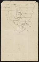
Title
-
Map of Austin's Little Colony above San Antonio Road
-
Identifier
-
camh-dob-013691
-
Creator
-
Austin, Stephen F. (Stephen Fuller), 1793-1836
-
Dates
-
1830
-
Box
-
2.325/V75
-
Folder
-
SA 69, 1830?
-
Resource
-
Stephen F. Austin map collection
-
Description
-
Sketch of plats of Austin's Little Colony above the Colorado River and San Antonio Road. Contains names and measurements of land allotted to colonists. Hand drawn. 46.5 x 44.5 cms. See Bound Collection of Title Plat Maps.
-

-
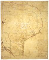
Title
-
Map of east Texas from the Gulf of Mexico to the Red River
-
Identifier
-
camh-dob-013562
-
Creator
-
Austin, Stephen F. (Stephen Fuller), 1793-1836
-
Dates
-
1827
-
Box
-
2AA1
-
Folder
-
SA 34, 1827?
-
Resource
-
Stephen F. Austin map collection
-
Description
-
Map of east Texas from the Gulf of Mexico to the Red River, with notes. 30.7 x 25 cms. Inset: Sketch of area about Pecan Point. 17 x 30.5 cms. On verso: Sketch of area about Bexar. 19.5 x 28 cms.
-

-
Title
-
Map of Indian Tribes along the Neches and Sabine Rivers
-
Identifier
-
camh-dob-013657
-
Creator
-
Austin, Stephen F. (Stephen Fuller), 1793-1836
-
Topic
-
Indians of North America
-
Dates
-
1827
-
Box
-
2AA1
-
Folder
-
SA 35, 1827?
-
Resource
-
Stephen F. Austin map collection
-
Description
-
Map of Indian Tribes along the Neches and Sabine Rivers, with notes. 25.2 x 19.7 cms. On verso: Map of Indian Tribes along the Colorado and Brazos Rivers. 25.2 x 19.7 cms.
-

-
Title
-
Map of North Central Texas
-
Identifier
-
camh-dob-013666
-
Creator
-
Austin, Stephen F. (Stephen Fuller), 1793-1836
-
Dates
-
1828
-
Box
-
2.325/V75
-
Folder
-
SA 44, 1822?
-
Resource
-
Stephen F. Austin map collection
-
Description
-
Map of North Central Texas detailing the waterways and general travel distances. The names of the streams are Comanche. 42.5 x 47.8 cms.
-
-
Title
-
Map of Northern Mexico between Monterrey and Laredo
-
Identifier
-
camh-dob-013667
-
Creator
-
Austin, Stephen F. (Stephen Fuller), 1793-1836
-
Dates
-
1828
-
Box
-
2AA1
-
Folder
-
SA 45, 1828?
-
Resource
-
Stephen F. Austin map collection
-
Description
-
Map of rivers, roads, and terrain in Northern Mexico between Monterrey and Laredo. Sketch was done in pencil, then overlayed with ink. 32 x 43. 5 cms.
-
-
Title
-
Map of Post Oak C
-
Identifier
-
camh-dob-013658
-
Creator
-
Austin, Stephen F. (Stephen Fuller), 1793-1836
-
Dates
-
1827
-
Box
-
3H242
-
Folder
-
Series V: Field Notes (2 of 2), SA 36
-
Resource
-
Stephen F. Austin map collection
-
Description
-
Map of Post Oak C showing land belonging to H. Yeamans, E.R. Wightman, G.W. Cash, et al.
-

-
Title
-
A Map of Rio Grande Country
-
Identifier
-
camh-dob-013669
-
Creator
-
Austin, Stephen F. (Stephen Fuller), 1793-1836
-
Dates
-
1828
1828
-
Box
-
2AA1
-
Folder
-
SA 19, 1823?; SA 20, 1824?; SA 47, 1828; SA 50, 1828?; SA 59, 1828?; SA 107, 1832, SA 47, 1828
-
Resource
-
Stephen F. Austin map collection
-
Description
-
A Map of Rio Grande Country, memo from Don Victor Blanco. 31.5 x 21.5 cms.
-

-
Title
-
Map of Texas by S. F. Austin
-
Identifier
-
camh-dob-013659
-
Creator
-
Austin, Stephen F. (Stephen Fuller), 1793-1836
-
Dates
-
1827
1827-08-08
-
Box
-
2.325/V75
-
Folder
-
SA 37, 1827
-
Resource
-
Stephen F. Austin map collection
-
Description
-
A map of Texas by Stephen F. Austin showing the southeast regions of Texas. It details the rivers of Texas and their tributaries, as well as major roads and settlements. Hand drawn. 42 x 41.7 cms.
-
-
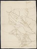
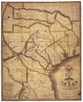
Title
-
Map of Texas by Stephen F. Austin
-
Identifier
-
foth_0630
-
Creator
-
Austin, Stephen F. (Stephen Fuller), 1793-1836
-
Dates
-
1829
-
Folder
-
SA 64
-
Description
-
Austin's detailed hand-drawn map showing the Austin and DeWitt colonies, various towns and rivers, and other natural features in Texas. Austin prepared the map sometime between 1823 and 1828 and based the map on firsthand observations as well as information gathered from travelers and surveyors.
-
-
Title
-
Map of Texas With Parts of the Adjoining States
-
Identifier
-
foth_0634
-
Creator
-
Austin, Stephen F. (Stephen Fuller), 1793-1836
-
Dates
-
1835
-
Description
-
The 1835 edition of Austin's 1830 Map of Texas, the first map to show on a large scale the beginnings of immigration into Texas from the United States. This later edition depicts additional land grants and presents a section of text stating the number of families to be located on each grant shown on the map.
-

-
Title
-
Map of the Rio Grande Country
-
Identifier
-
camh-dob-013670
-
Creator
-
Austin, Stephen F. (Stephen Fuller), 1793-1836
-
Dates
-
1828
-
Box
-
2AA1
-
Folder
-
SA 48, 1828?
-
Resource
-
Stephen F. Austin map collection
-
Description
-
Map of the Rio Grande Country in Mexico. 32.5 x 44 cms.
-

-
Title
-
A Map showing Martin M. Kenney's Plat
-
Identifier
-
camh-dob-013732
-
Creator
-
Austin, Stephen F. (Stephen Fuller), 1793-1836
-
Dates
-
1833
-
Box
-
2AA1
-
Folder
-
SA 110, 1833?
-
Resource
-
Stephen F. Austin map collection
-
Description
-
A Map showing Martin M. Kenney's Plat with faint notes in pencil. 31.8 x 39.5 cms.
