- Prints and photographs collection (x)
- Cartography (x)
- Austin, Stephen F. (Stephen Fuller), 1793-1836 (x)
- Search results
-

-
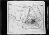
Title
-
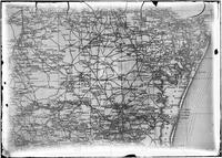
Annotated map from Army Corp of Engineers depicting the improvements needed for the Sabine Neches waterway, circa 1953
-
Identifier
-
camh-dob-001455
-
Topic
-
United States--Sabine-Neches Waterway, Intracoastal waterways
-
Dates
-
1953
-
Resource
-
Jack B. Brooks papers
-
Description
-
The map, originally printed by the Army Corps of Engineers in 1938, depicts the Sabine-Neches waterway and the surrounding area. The locations of proposed improvements to the waterway are marked in red pencil.
-

-
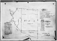
Title
-
The Bingamen Bottom Place
-
Identifier
-
camh-dob-013624
-
Creator
-
Austin, Moses, 1761-1821
-
Dates
-
1791
-
Resource
-
Stephen F. Austin map collection
-
Description
-
Sketch of survey of Bingamen Bottom Place in Wythe County, Virginia. 25 x 24 cms. In colored outline.
-

-
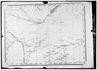
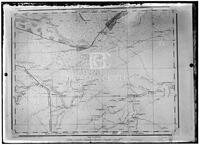
Title
-
Caldwell Survey
-
Identifier
-
camh-dob-013726
-
Creator
-
Wightman, Elias R., 1792-1841
-
Dates
-
1831
-
Resource
-
Stephen F. Austin map collection
-
Description
-
Sketch of survey of Cedar Lake and Bernard showing J.P. Caldwell's survey. 30 x 36 cms.
-

-
Title
-
Cedar Lake Survey
-
Identifier
-
camh-dob-013654
-
Dates
-
1826
-
Resource
-
Stephen F. Austin map collection
-
Description
-
Survey of Cedar Lake area including timberland and marshland or wet prairie. 35 x 20 cms. On verso: "Cedar Lake Survey" inscription.
-

-
Title
-
John V. Clay map collection
-
Identifier
-
camh_voc_029305
-

-
Title
-
Copias de los diarios de operaciones des occurridas en este destacamto
-
Identifier
-
camh-dob-013653
-
Dates
-
1824, 1824
-
Resource
-
Stephen F. Austin map collection
-
Description
-
Sketch of the Villa de San José de Palafox. Inscribed on verso in Spanish with "Copias de los diarios de operaciones des occurridas en este destacamto... 13 oficios del...de la linea...en tiempo...Capt. Barragan." 31 x 21.5 cms. Note: The Villa is adjacent to Presidio de Rio Grande. See Bastrop's letter to Ceballos, 22 August 1825, in Barker, The Austin Papers, I, 965.
-

-
Title
-
Copy Photo: Garden plat, Santa Luisa, Brownsville
-
Identifier
-
RUN07790
-
Creator
-
Runyon, Robert
-
Resource
-
Robert Runyon photograph collection
-

-
Title
-
Copy Photo: Map of La Carbonera and El Cureno. January 1899
-
Identifier
-
RUN07789
-
Creator
-
Runyon, Robert
-
Resource
-
Robert Runyon photograph collection
-
-
Title
-
Copy Photo: Map of La Carbonera and El Cureno, January 1899
-
Identifier
-
RUN07791
-
Creator
-
Runyon, Robert
-
Resource
-
Robert Runyon photograph collection
-
-
Title
-
Copy Photo: Map of Matamoros
-
Identifier
-
RUN07787
-
Creator
-
Runyon, Robert
-
Resource
-
Robert Runyon photograph collection
-
-
Title
-
Copy Photo: Map of Matamoros
-
Identifier
-
RUN07788
-
Creator
-
Runyon, Robert
-
Resource
-
Robert Runyon photograph collection
-

-
Title
-
Copy Photo: Map of Matamoros, 1915
-
Identifier
-
RUN07786
-
Creator
-
Runyon, Robert
-
Resource
-
Robert Runyon photograph collection
-
-
Title
-
Copy Photo: Map of Mexico
-
Identifier
-
RUN07778
-
Creator
-
Runyon, Robert
-
Resource
-
Robert Runyon photograph collection
-
-
Title
-
Copy Photo: Map of Mexico
-
Identifier
-
RUN07779
-
Creator
-
Runyon, Robert
-
Resource
-
Robert Runyon photograph collection
-
-
Title
-
Copy Photo: Map of Mexico
-
Identifier
-
RUN07780
-
Creator
-
Runyon, Robert
-
Resource
-
Robert Runyon photograph collection
-
-
Title
-
Copy Photo: Map of Mexico
-
Identifier
-
RUN07781
-
Creator
-
Runyon, Robert
-
Resource
-
Robert Runyon photograph collection
-

-
Title
-
Copy Photo: Map of Mexico
-
Identifier
-
RUN07782
-
Creator
-
Runyon, Robert
-
Resource
-
Robert Runyon photograph collection
-
-
Title
-
Copy Photo: Map of Mexico
-
Identifier
-
RUN07783
-
Creator
-
Runyon, Robert
-
Resource
-
Robert Runyon photograph collection
-

-
Title
-
Copy Photo: Map of Mexico, 1917
-
Identifier
-
RUN07774
-
Creator
-
Runyon, Robert
-
Resource
-
Robert Runyon photograph collection
-

-
Title
-
Copy Photo: Map of Mexico, 1917
-
Identifier
-
RUN07775
-
Creator
-
Runyon, Robert
-
Resource
-
Robert Runyon photograph collection
