- Texas History (x)
- Manuscript maps (x)
- 1828 (x)
- Search results
-

-
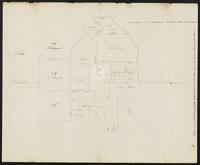
Title
-
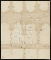
Actual work to Correct the Maps by Cronkrite
-
Identifier
-
camh-dob-013650
-
Creator
-
Austin, Stephen F. (Stephen Fuller), 1793-1836
-
Dates
-
1824
-
Box
-
2AA1
-
Folder
-
SA 27, 1824?
-
Resource
-
Stephen F. Austin map collection
-
Description
-
Sketch of plats along the upper Tres Palacios Creek in Matagorda and Waller Counties. 32 x 40.2 cms. On verso: Actual work to correct the maps by Cronkite.
-
-
Title
-
Caldwell Survey
-
Identifier
-
camh-dob-013726
-
Creator
-
Wightman, Elias R., 1792-1841
-
Dates
-
1831
-
Box
-
2AA1
-
Folder
-
SA 104, 1831?
-
Resource
-
Stephen F. Austin map collection
-
Description
-
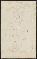
Sketch of survey of Cedar Lake and Bernard showing J.P. Caldwell's survey. 30 x 36 cms.
-

-
Title
-
Capt. Adams Draft of the Coasts and Bay, Corpus Christy, 1827
-
Identifier
-
camh-dob-013743
-
Creator
-
Austin, Stephen F. (Stephen Fuller), 1793-1836
-
Dates
-
1827
1827
-
Box
-
2AA1
-
Folder
-
SA 121, 1827?
-
Resource
-
Stephen F. Austin map collection
-
Description
-
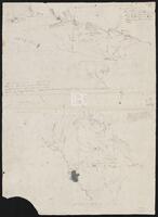
Draft of the Coasts and Bay, Corpus Christy. This map was found by a patron in a different collection and is believed to be a map from the Stephen F. Austin Collection. 32 x 30 cms. On verso: "Capt. Adams Draft of the Coast and Bay, Corpus Christy, 1827" inscription.
-

-
Title
-
Cedar Lake Survey
-
Identifier
-
camh-dob-013654
-
Dates
-
1826
-
Box
-
2AA1
-
Folder
-
Field Notes Book 124 - Cedar Lake Survey - SA 31, 1826?
-
Resource
-
Stephen F. Austin map collection
-
Description
-
Survey of Cedar Lake area including timberland and marshland or wet prairie. 35 x 20 cms. On verso: "Cedar Lake Survey" inscription.
-

-
Title
-
Copias de los diarios de operaciones des occurridas en este destacamto
-
Identifier
-
camh-dob-013653
-
Dates
-
1824
1824
-
Box
-
2AA1
-
Folder
-
SA 30, 1824
-
Resource
-
Stephen F. Austin map collection
-
Description
-
Sketch of the Villa de San José de Palafox. Inscribed on verso in Spanish with "Copias de los diarios de operaciones des occurridas en este destacamto... 13 oficios del...de la linea...en tiempo...Capt. Barragan." 31 x 21.5 cms. Note: The Villa is adjacent to Presidio de Rio Grande. See Bastrop's letter to Ceballos, 22 August 1825, in Barker, The Austin Papers, I, 965.
-
-
Title
-
Jones Plott
-
Identifier
-
camh-dob-013648
-
Creator
-
Austin, Stephen F. (Stephen Fuller), 1793-1836
-
Dates
-
1824
-
Box
-
2AA1
-
Folder
-
SA 25, 1824?
-
Resource
-
Stephen F. Austin map collection
-
Description
-
Sketch of Jones plot in Wharton County with notes and calculations. 23.2 x 36.8 cms. Some lines drawn in pencil.
-

-
Title
-
Map of a part of DeWitt's Colony
-
Identifier
-
camh-dob-013684
-
Creator
-
Austin, Stephen F. (Stephen Fuller), 1793-1836
-
Dates
-
1829
-
Box
-
2AA1
-
Folder
-
SA 62, 1829[?]
-
Resource
-
Stephen F. Austin map collection
-
Description
-
Sketch of Colorado and Rio Grande Rivers with notes. On verso: Map of a part of DeWitt's Colony, showing the area about Gonzales, Bastrop and DeWitt's Station. 28 x 26 cms.
-

-
Title
-
Map of Austin's Little Colony above San Antonio Road
-
Identifier
-
camh-dob-013691
-
Creator
-
Austin, Stephen F. (Stephen Fuller), 1793-1836
-
Dates
-
1830
-
Box
-
2.325/V75
-
Folder
-
SA 69, 1830?
-
Resource
-
Stephen F. Austin map collection
-
Description
-
Sketch of plats of Austin's Little Colony above the Colorado River and San Antonio Road. Contains names and measurements of land allotted to colonists. Hand drawn. 46.5 x 44.5 cms. See Bound Collection of Title Plat Maps.
-
-
Title
-
Map of east Texas from the Gulf of Mexico to the Red River
-
Identifier
-
camh-dob-013562
-
Creator
-
Austin, Stephen F. (Stephen Fuller), 1793-1836
-
Dates
-
1827
-
Box
-
2AA1
-
Folder
-
SA 34, 1827?
-
Resource
-
Stephen F. Austin map collection
-
Description
-
Map of east Texas from the Gulf of Mexico to the Red River, with notes. 30.7 x 25 cms. Inset: Sketch of area about Pecan Point. 17 x 30.5 cms. On verso: Sketch of area about Bexar. 19.5 x 28 cms.
-

-
Title
-
Map of Indian Tribes along the Neches and Sabine Rivers
-
Identifier
-
camh-dob-013657
-
Creator
-
Austin, Stephen F. (Stephen Fuller), 1793-1836
-
Topic
-
Indians of North America
-
Dates
-
1827
-
Box
-
2AA1
-
Folder
-
SA 35, 1827?
-
Resource
-
Stephen F. Austin map collection
-
Description
-
Map of Indian Tribes along the Neches and Sabine Rivers, with notes. 25.2 x 19.7 cms. On verso: Map of Indian Tribes along the Colorado and Brazos Rivers. 25.2 x 19.7 cms.
-
-
Title
-
Map of Oyster Lake and adjacent area showing the H. Curtis Labor
-
Identifier
-
camh-dob-013737
-
Dates
-
1837
1837
-
Box
-
3H242
-
Folder
-
Series V: Field Notes (1 of 2), SA 115
-
Resource
-
Stephen F. Austin map collection
-
Description
-
Map of Oyster Lake and adjacent area showing the H. Curtis Labor. 21 x 32 cms. On verso: notes and calculations.
-

-
Title
-
Map of Post Oak C
-
Identifier
-
camh-dob-013658
-
Creator
-
Austin, Stephen F. (Stephen Fuller), 1793-1836
-
Dates
-
1827
-
Box
-
3H242
-
Folder
-
Series V: Field Notes (2 of 2), SA 36
-
Resource
-
Stephen F. Austin map collection
-
Description
-
Map of Post Oak C showing land belonging to H. Yeamans, E.R. Wightman, G.W. Cash, et al.
-

-
Title
-
Map of Texas by S. F. Austin
-
Identifier
-
camh-dob-013659
-
Creator
-
Austin, Stephen F. (Stephen Fuller), 1793-1836
-
Dates
-
1827
1827-08-08
-
Box
-
2.325/V75
-
Folder
-
SA 37, 1827
-
Resource
-
Stephen F. Austin map collection
-
Description
-
A map of Texas by Stephen F. Austin showing the southeast regions of Texas. It details the rivers of Texas and their tributaries, as well as major roads and settlements. Hand drawn. 42 x 41.7 cms.
-
-
Title
-
Map of the correction when the leagues were run in to the meanders of San Jacinto
-
Identifier
-
camh-dob-013708
-
Dates
-
1830
-
Box
-
2AA1
-
Folder
-
SA 86, 1830?
-
Resource
-
Stephen F. Austin map collection
-
Description
-
Correcting map of plats near the San Jacinto river. 39.5 x 27 cms. Verso is inscribed with "Map of correction when The Leagues were run in to the meanders of San Jacinto."
-
-
Title
-
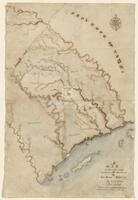
A map of the country, between the Brassos & La Baca Rivers By N. Rightor
-
Identifier
-
camh-dob-013637
-
Creator
-
Rightor, Nicholas
-
Dates
-
1822
1822
-
Box
-
2.325/V75
-
Folder
-
SA 14, 1822
-
Resource
-
Stephen F. Austin map collection
-
Description
-
A map of the Province of Texas, between the Brazos & Lavaca Rivers. Details the major waterways in the southeast region of Texas as they flow into the Gulf of Mexico. Hand drawn, in colors. Water is shaded blue. 1 inch = 10 miles. 24.2 x 36.6 cms.
-
-
Title
-
Map of the head waters of San Jacinto disjoined from the other surveys
-
Identifier
-
camh-dob-013711
-
Dates
-
1830
-
Box
-
2AA1
-
Folder
-
SA 89
-
Resource
-
Stephen F. Austin map collection
-
Description
-
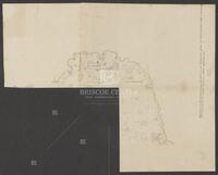
Map of plats inscribed with "This map is the head waters of San Jacinto disjoined from the other surveys. Only a connecting line runs to prove its relative situation, called upper surveys." Shows plats of Susan Vince, James Ford, and heirs of William Hodge. May be missing pieces. 39 x 35 cms. Shading in pencil.
-

-
Title
-
A Map showing Martin M. Kenney's Plat
-
Identifier
-
camh-dob-013732
-
Creator
-
Austin, Stephen F. (Stephen Fuller), 1793-1836
-
Dates
-
1833
-
Box
-
2AA1
-
Folder
-
SA 110, 1833?
-
Resource
-
Stephen F. Austin map collection
-
Description
-
A Map showing Martin M. Kenney's Plat with faint notes in pencil. 31.8 x 39.5 cms.
-

-
Title
-
Map showing part of the Rio Grande River above Nava and Ligido
-
Identifier
-
camh-dob-013643
-
Creator
-
Austin, Stephen F. (Stephen Fuller), 1793-1836
-
Dates
-
1824
-
Box
-
2AA1
-
Folder
-
SA 19, 1823?; SA 20, 1824?; SA 47, 1828; SA 50, 1828?; SA 59, 1828?; SA 107, 1832, SA 20, 1824?
-
Resource
-
Stephen F. Austin map collection
-
Description
-
Map showing part of the Rio Grande River above Nava and Ligido. 11 x 20 cms.
-
-
Title
-
Mapa del pais de los Comanches, formado por el C. Estevan Austin pa esplicar el plan de campana contra d'hos Indios
-
Identifier
-
camh-dob-013660
-
Creator
-
Austin, Stephen F. (Stephen Fuller), 1793-1836
-
Topic
-
Indians of North America, Comanche Indians
-
Dates
-
1827
1827-08-28
-
Folder
-
SA 38
-
Resource
-
Stephen F. Austin map collection
-
Description
-
Prototype map of Texas covering the area between Bexar and the Red River, with notes about a campaign against the Comanches. 41.5 x 58.5 cms.
-

-
Title
-
Mapa Geográfico de la Provincia Tehas par Don Estevan Austin, 1822
-
Identifier
-
camh-dob-013634
-
Creator
-
Austin, Stephen F. (Stephen Fuller), 1793-1836
-
Dates
-
1822
1822
-
Folder
-
SA 11
-
Resource
-
Stephen F. Austin map collection
-
Description
-
Mapa Geográfico de la Provincia Tehas par Don Estevan Austin 1822. 64 x 50 cms. In colors.
