- Texas History (x)
- Manuscript maps (x)
- 1824 (x)
- Search results
-

-
Title
-
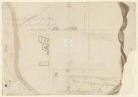
Actual work to Correct the Maps by Cronkrite
-
Identifier
-
camh-dob-013650
-
Creator
-
Austin, Stephen F. (Stephen Fuller), 1793-1836
-
Dates
-
1824
-
Box
-
2AA1
-
Folder
-
SA 27, 1824?
-
Resource
-
Stephen F. Austin map collection
-
Description
-
Sketch of plats along the upper Tres Palacios Creek in Matagorda and Waller Counties. 32 x 40.2 cms. On verso: Actual work to correct the maps by Cronkite.
-
-
Title
-
Copias de los diarios de operaciones des occurridas en este destacamto
-
Identifier
-
camh-dob-013653
-
Dates
-
1824
1824
-
Box
-
2AA1
-
Folder
-
SA 30, 1824
-
Resource
-
Stephen F. Austin map collection
-
Description
-
Sketch of the Villa de San José de Palafox. Inscribed on verso in Spanish with "Copias de los diarios de operaciones des occurridas en este destacamto... 13 oficios del...de la linea...en tiempo...Capt. Barragan." 31 x 21.5 cms. Note: The Villa is adjacent to Presidio de Rio Grande. See Bastrop's letter to Ceballos, 22 August 1825, in Barker, The Austin Papers, I, 965.
-

-
Title
-
Jones Plott
-
Identifier
-
camh-dob-013648
-
Creator
-
Austin, Stephen F. (Stephen Fuller), 1793-1836
-
Dates
-
1824
-
Box
-
2AA1
-
Folder
-
SA 25, 1824?
-
Resource
-
Stephen F. Austin map collection
-
Description
-
Sketch of Jones plot in Wharton County with notes and calculations. 23.2 x 36.8 cms. Some lines drawn in pencil.
-

-
Title
-
Map showing part of the Rio Grande River above Nava and Ligido
-
Identifier
-
camh-dob-013643
-
Creator
-
Austin, Stephen F. (Stephen Fuller), 1793-1836
-
Dates
-
1824
-
Box
-
2AA1
-
Folder
-
SA 19, 1823?; SA 20, 1824?; SA 47, 1828; SA 50, 1828?; SA 59, 1828?; SA 107, 1832, SA 20, 1824?
-
Resource
-
Stephen F. Austin map collection
-
Description
-
Map showing part of the Rio Grande River above Nava and Ligido. 11 x 20 cms.
-
-
Title
-
Plat to Survey by no returns can be made till Bowman & Williams League is settled
-
Identifier
-
camh-dob-013644
-
Creator
-
Austin, Stephen F. (Stephen Fuller), 1793-1836
-
Dates
-
1824
1824
-
Box
-
2AA1
-
Folder
-
SA 21, 1824
-
Resource
-
Stephen F. Austin map collection
-
Description
-
Plat to survey in Matagorda County. 30.5 x 26 cms.
-

-
Title
-
Plot of Payton C.
-
Identifier
-
camh-dob-013645
-
Creator
-
Austin, Stephen F. (Stephen Fuller), 1793-1836
-
Dates
-
1824
-
Box
-
2AA1
-
Folder
-
SA 22, 1824?
-
Resource
-
Stephen F. Austin map collection
-
Description
-
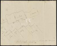
Plot of Payton C. showing plats of D. Rawls, A. Rawls, and others in Matagorda and Wharton Counties. 33 x 40.3 cms.
-

-
Title
-
Plot of San Bernard and Peach Creek
-
Identifier
-
camh-dob-013646
-
Creator
-
Austin, Stephen F. (Stephen Fuller), 1793-1836
-
Dates
-
1824
-
Box
-
2.325/V75
-
Folder
-
SA 23, 1824?
-
Resource
-
Stephen F. Austin map collection
-
Description
-
Plot of the San Bernard River and Peach Creek. 60 x 19.4 cms.
-

-
Title
-
Plot of tract of Prairie and other Minutes
-
Identifier
-
camh-dob-013651
-
Creator
-
Austin, Stephen F. (Stephen Fuller), 1793-1836
-
Dates
-
1824
-
Box
-
2AA1
-
Folder
-
SA 28
-
Resource
-
Stephen F. Austin map collection
-
Description
-
Plot of prairie between Peach Creek and the Colorado River, with notes. 31 x 41 cms.
-

-
Title
-
Sketch of area about Barker's Corner
-
Identifier
-
camh-dob-013647
-
Creator
-
Austin, Stephen F. (Stephen Fuller), 1793-1836
-
Dates
-
1824
-
Box
-
3H242
-
Folder
-
Series V: Field Notes (1 of 2), SA 24
-
Resource
-
Stephen F. Austin map collection
-
Description
-
Sketch of area about Barker's Corner. 21 x 16 cms.
